
Arizona Trail
My Arizona Trail Hike
I hiked the Arizona Trail from March 17, 2012 to April 28, 2012.
I took 1,699,035 steps to travel about 800 miles.
Journal Photos Map Gear Food Expenses Supporters Stats
My Gear
My pack weighed 17 to 28 pounds, depending on how many days of food and miles of water I carried. There was an additional 4lbs of clothes on my body.
| Item | Oz | $$ | Notes |
| G4 backpack | 16 | $40 | 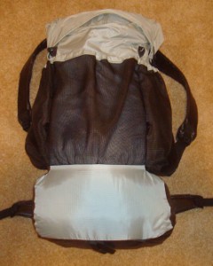 made myself from pattern. made myself from pattern.Worked much better than I ever hoped. Comfortable, light, and plenty of room for all my gear. |
| Sleeping | |||
| shelter | 23 | $75 | made myself, includes plastic groundsheet and 8 stakes. Great little shelter but did not get stress-tested by any bad weather. My next one will have a few changes, but the general design is just what I like. |
| sleeping quilt | 40 | $105 | 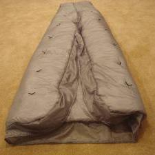 made myself from pattern, birthday present. made myself from pattern, birthday present.Too warm most of the time! Worked super. |
| Synmat 7 UL Pad | 16.2 | $155 | Two baffles popped, making it uncomfortable but usable. It got no leaks the entire trip. ExPed sent me a replacement when I got home! |
| Exped pillow | 2.7 | $20.50 | 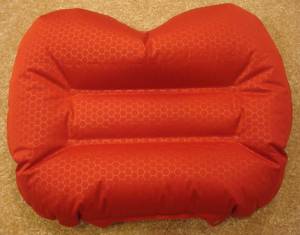 xmas present. xmas present.I believe this really helped me sleep and was worth the extra bit of weight. |
| sleeping hat | 1.5 | $26 | made myself, xmas present. Since I had a hood on my down coat, I didn't need this. |
| Cooking | |||
| alcohol stove | 1.1 | $10 | messier than I had hoped. Used more fuel than expected. Did not carry for last 2 weeks - no cooking. |
| cook kit | 5.8 | $25 | includes spoon, pot, foil lid, stand, windscreen, and lighter. |
| 8oz bottle | .9 | $3 | |
| food cozy | .8 | $0 | homemade. No complaints, saved fuel and got food soft and hot. |
| food | 0-9lb. | $0 | I carried 6 days of food at the most. |
| fuel | 7 | $0 | up to 7 oz. of alcohol, but usually less. |
| Water | |||
| pre-filter | 1.2 | $1 | homemade did not work. Still more work to do on it. |
| water filter | 4.2 | $51.70 | Sawyer filter and raw water bag. Water bag got a few pinholes and delaminated at opening. |
| water bottles | 1.8 | $16 | 2 1L Platypus roll-ups. no problems. |
| soda bottles | 1.2 | $0 | 2 .6L hard. cheap, easy, light, no problems. |
| water | 0-12.1lb. | 5.5L on the longest stretch, 2.2lb/L | |
| Clothes | |||
| down coat | 21 | $120 | my big splurge. Used it every night as soon as the sun set. |
| long-sleeve shirt | 9 | wore every day and the shoulders have worn through from the pack straps. | |
| gaiters | 1.4 | $19 | Dirty Girl gaiters |
| BSA zip-off pants | 17.2 | wore every day. | |
| liner socks | 2.8 | 2pr. | |
| BSA socks | 3.8 | 2pr. ankle socks | |
| shoes | 28 | $32 | one pair wore out after 450 miles. Second pair doing fine. |
| underwear | 4.2 | 2pr. wore them out | |
| BSA hat | 3.5 | wore it every day with homemade sun shield. | |
| bandanna | 1.0 | only used a couple times | |
| BSA t-shirt | 5.6 | for in-town wear | |
| BSA short pants | 11.9 | for in-town wear | |
| long underwear | 12.4 | top & bottom | |
| Electronics | |||
| cellphone | 4.3 |  borrowed from friend. Worked super for blogging daily with pictures. borrowed from friend. Worked super for blogging daily with pictures. | |
| camera | 5.4 | old digital SONY | |
| tracker | 5.1 | pings to satellite with my location. Batteries lasted about 10-14 days when on for 12 hours/day. | |
| solar charger | 7.3 | 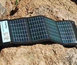 Kept cellphone charged just fine. Stopped working in Grand Canyon and still broken. Kept cellphone charged just fine. Stopped working in Grand Canyon and still broken. | |
| Other | |||
| umbrella | 8.1 | $35 | used about 8 days for desert sun. Worked wonderfully to keep cool. |
| pedometer | .6 | $25 | 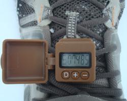 wore every day to track steps. wore every day to track steps. |
| rain poncho | 1.7 | $2 | cheap disposable. Used twice in snow. |
| maps | 2 | $25 |  up to 1 week of maps at a time. Used all the time to track location. up to 1 week of maps at a time. Used all the time to track location. |
| 1st aid kit | 2.3 | used for blisters | |
| pad repair kit | .4 | used to patch water bottle | |
| compass | 1.1 | only used 2 or 3 times. | |
| knife | 1.1 | tiny, single blade. | |
| toothbrush | 1.3 | includes paste | |
| ear plugs | 0 | never used | |
| 50ft. core | 1.5 | used once to hang food | |
| toilet kit | 2.8 | TP, Purell - had trowel at start, but left it. | |
| trek poles | 19.4 | $30 |  inexpensive and wore out the tips. Should have lasted longer. Used to support shelter also. inexpensive and wore out the tips. Should have lasted longer. Used to support shelter also. |
| headlamp | .5 | $11 | 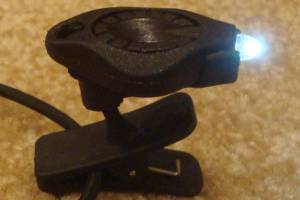 Awesome photon light. Batteries lasted about 12 hours, so I replaced each week. Awesome photon light. Batteries lasted about 12 hours, so I replaced each week. |
| Stick Pic | .4 | self-pictures and videos | |
| misc. | 2.8 | 2 garbage bags, whistle, clippers, thermometer | |
| Total | 19lbs 4lbs were worn, not in pack 15lb pack weight 2 to 13lb food & water 17 to 28lb - total pack weight | ||
My Food
My daily menu was:
- Breakfast: 2 poptarts - 400 calories
- Lunch: peanut butter and honey mixed, on ritz crackers - 650 calories
- Snacks: Trail mix - 750, 2 candy bars - 560 calories
- Dinner: Knorr noodles or rice, salmon or tuna or chicken pouch, 1 oz. olive oil - 700 calories
- Drink: mostly water, gatorade - 100 calories
- Daily vitamin
For the last 10 days, I left my cook kit behind to lighten my load and only ate cold food, replacing the dinner with 2 Snickers bars. But, I had access to restaurants and fresh food often, too.
My Expenses
This is very close, but I expect there were a couple other expenses. The $$/mile is high because travel to/from the trail was expensive. A longer trail would have that base cost distributed over more miles.
- travel - $565 - air MSP to Tucson $210, trailend to Phoenix $200, air Phoenix to MSP - $155
- gear - $350 - I got lots of birthday and Christmas presents so had little expense for gear
- maps - $25 - terrific mapset from simblissity.net covered the entire trail and profits go to the AZT Association.
- food - $294 - groceries in towns and for the trail
- restaurants - $170.68
- lodging - $352.48 - Patagonia $89.74, Patagonia $89.74, Oracle $42.64, Mormon Lake $58.18, Jacob Lake $72.18. Stayed with friends and Scouting families about 8 nights.
- Grand Canyon camping - $21 - $6 at Mather campground, $15 at Cottonwood camp
- fun - $486.57 - thank you meals with host families, going out on the town zero days and after trek.
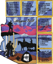
- souvenirs - $29 - BSA patch set
- shipping - $36.49 - bounce box and shoes
- Total - $2350 - almost $3/mile.
$2.50/mile without gear costs since I can still use that.
$1.10/mile for food and lodging.
You Asked
Questions you asked about my hike. Got one? - Ask It
Arizona Trail Statistics
| States | Arizona | ||||||||||||||||
| Distance | 800 miles - trail reroutes happen so this is an estimate of the trail length. | ||||||||||||||||
| Total Elevation | |||||||||||||||||
| Terminus | South: Coronado Nat'l monument on Mexican border North:Utah border | ||||||||||||||||
| Highest Point | AZ Snow Bowl on San Francisco mountain, about 9270ft | ||||||||||||||||
| Lowest Point | Gila river, 1700ft | ||||||||||||||||
| Map | 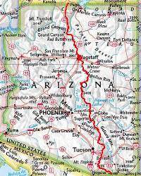 Click for Large Map | ||||||||||||||||
| Terrain | desert with high daily temperatures and low night temperature. Travel through mountain ranges as well as many miles of fairly level plateaus. Many prickly, scratchy plants which can be hard on clothing. The trail is complete, but not well-traveled in spots. | ||||||||||||||||
| History | designated in 2009 and completed in 2011. | ||||||||||||||||
| Challenges | water sources are scarce, extreme temperature fluctuations from day to night, potential dangers from illegal alien traffic at southern end, rim-to-rim of Grand Canyon, common snow cover north of Grand Canyon | ||||||||||||||||
| Time Window | February to May. Start too early and you'll be hampered by deep snow, too late and the desert will have no water. Most thru-hikers go March through April, northbound. | ||||||||||||||||
| Time to Hike | Typically takes 40-50 days. Speed record set in 2011 is 21 days. | ||||||||||||||||
| Permits | Saguaro National Park and Grand Canyon National Park require permits for camping. An optional AZT permit can be obtained to allow the thru-hiker to camp outside a 15-foot corridor along the trail through State Land Trust areas. (I purchased this permit to support the AZT, but I have no idea why anyone would ever need it.) | ||||||||||||||||
| Thru-hiker Tally | less than 100, no award or recognition for thru-hiking or section hiking | ||||||||||||||||
Trail Links | |||||||||||||||||
| Google Earth | View Trail with google earth | ||||||||||||||||
| Full Maps | |||||||||||||||||
| Agencies | Arizona Trail Association
| ||||||||||||||||
Land Managers of the Arizona Trail
Patches
| |||||||||||||||||
Hike On: My Hikes
All Comments:
Mar 29, 2014 - Glenn Beachy
This is really useful information. Thank you! I plan to start at the Utah border and do the first 100 miles this Sept with a couple old guys like myself. That would end at the South Rim of the Grand Canyon. If we can't get a campsite at Cottonwood or Bright Angel we will try to get our gear shuttled and do a rim to rim to finish the trip. That I have done before, South to North, about 11 hrs. They warn you not to but if you are in shape, plan accordingly and don't take too long rests it is not a killer hike. Lots of folks do it nearly every day in the hiking season. It looks like there is not much elevation change that first 80 miles. Any advice through that stretch? Did you go see "The Wave" rock formation near the end of your hike?
Apr 06, 2014 - Hiking Dude
@Glenn - When I reached the border, I was ready to be done so I didn't see the Wave or any other attractions. :-)
As far as that last stretch (or first stretch for you), right out of the campground you have a 2-mile hike up switchbacks to gain 1000 feet elevation. If you could start early in the am, that would help you a lot. After that, it's 65 miles to gradually gain 3000 feet to the G.C. boundary across the Kaibab Plateau. There were lots of burned and logged areas, but also some pretty nice stretches.
Aug 17, 2015 - Zarem
Thinking about doing this trip next year around March/April
time frame.
Ask a Question
Find more Hiking Resources at www.HikingDude.com


Follow Me
Recent Comments