
Hiking Dude Blog
2025 - Aug Jul
2024 2023 2022 2021 2020 2019 2018 2017 2016 2015 2014 2013 2012 2011
03/06/2012
Trail Journal
 The lake has puddles on the ice after this 60 degree day. What an amazingly beautiful day for a nice hike.
I traveled about 11 miles today.
Check out my current location on the map.
03/05/2012
Trail Journal
 I hiked 4 miles to Gander Mountain to pick up three 1-liter platypus water bags. They weigh about 5 ounces all together and take up very little space when rolled up. I'll have them as extra storage in case water is more scarce than I imagine and for a couple of looooong dry stretches.
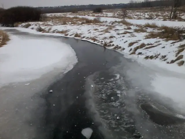
I hiked over this frozen river and dropped a big snowball on it just for fun.
Hike On
Leave Comment
Posted: 03/05/2012
Posted: 03/05/2012
03/02/2012
Electronics Prep

Very busy couple days getting electronics gear ready for the AZT.
A friend figured out that I could just use his cellphone that he just keeps forwarded to another work phone, so I don't have to buy one or add a line to our plan. (My family all have phones, but not me) It's good to have generous friends like this one!
We tested out all the possible situations that might occur while I have his phone and he still has calls coming in - I'm sending a text, I'm talking, I have the phone off/on/airplane. We checked that texts and calls I make go through and texts come to me, but calls continue to forward to his other phone. It all works just as we hoped. Pretty cool!
So, today I did the coding for my autoblog on my website. I can now send a text message from the trail and it becomes a blog entry. I can compose a text in airplane mode or without a cell signal and it will be held until it can be sent. The only thing I still need to tweak is including a photo - it almost works.
I should be able to send you all great updates as I
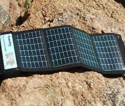 I also tested the solar charger with the phone. The Boy Scouts provided me with this charger and I really appreciate their support of my hike. It has two AA batteries in it plus a USB port.
The charger is made by PowerFilm and will most likely spend most of its time hanging on my backpack or my umbrella.
It makes sense to use a solar charger in Arizona, especially when I'll be hiking generally north the whole time. When I get back from this hike, I think you'll be interested to hear about my new power source for my Ice Age Trail if it gets released.
Hike On
Leave Comment
Posted: 03/02/2012
Posted: 03/02/2012
02/28/2012
What I Really Do - AZ Trail
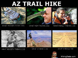
Click the image for a larger view.
Which one do you think of when you hear someone is hiking 800 miles across Arizona?
Hike On
02/27/2012
I Love It When...
 ... a plan comes together.
This weekend was a flurry of progress on final plans for my AZ Trail hike. Still a lot more to do, but big progress.
- A Buddy: For the first few days at least, from the Mexico border to Patagonia, I'll be hiking with Colton. I met his dad online, chatted on the phone, and talked with Colton today. Sounds like a great guy and we've got similar goals and plans for our hikes. It's good to have someone else on the trail, especially in that part of the state, so I'm told. My mom can relax now.
- A Flight: I bought my plane tickets from MSP to Tucson, arriving on March 15.
The travel industry is crazy. I had an alert set up on kayak.com and the prices went up and down daily like a yo-yo for two weeks. I wound up paying $160 for a one-way ticket. I'll get my return flight when I'm nearly done with the hike. - A Room: a friend from college is letting me bunk overnight in Tucson. I'll have Friday to buy food, ship a package down the trail, and do last minute stuff.
- A Start Date: We're hitting the trail at about 6:00am on St. Patrick's Day - how cool is that? Gives us a long day to make our first miles.
So, the actual plans for the hike are pretty much done. Now, I just have to actually do it. The rest of my To Do list are support things, like enabling my ability to blog from the trail, email subscribers to my updates, map tracking, and other fun stuff.
Oh yeah, we're supposed to get a foot of snow tomorrow so I'll be taking a few rest days from hiking.
I'm visiting a scout meeting tonight to tell them about my hike, show my gear, and promote the ScoutStrong Program.
Hike On
02/24/2012
2nd Quilt
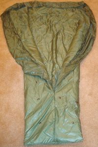 It may be too light for my AZ hike, but I expect it to be perfect for summer backpacking on the Ice Age Trail in Wisconsin. This sleeping quilt has only almost 1 inch of loft, but takes up a lot less space than my first quilt so it's tempting to try it earlier. I'll test it outside this weekend and see how warm I stay.
It's green rip-stop nylon and a bit shorter and skinnier than my first in an effort to reduce weight. It weighs 1lb. 15oz. I was hoping it would weigh less, but I think the insulation I used is heavier for the amount of loft - in other words, not as good as expected.
The quality of insulation is really key to a warm quilt with less weight. Down has the best loft to weight ratio, but messy to work with, expensive, and loses loft when moist.
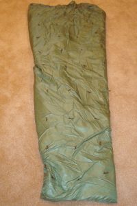 This synthetic insulation will maintain loft better when wet which makes me a bit more comfortable on a long trek. Hopefully, I'll never find out just how well it holds up. :-)
It only took me about 2 hours to make this quilt. Since it's mostly just long, straight stitches, there's not much to it. Keeping the many thick layers laying flat and in line is the most difficult part.
Fortunately, my neighbor had some extra brown yarn for the quilting laying around when I found out we had none. It's a good thing I'm leaving on my hike soon or I'd probably wind up making a third quilt somewhere between the first two in thickness.
Hike On
02/23/2012
DIY Pack
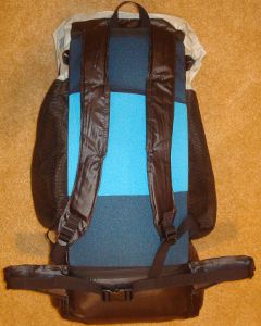 Yes, Mom, I made it myself!
With very little seam ripping and only two permanent alterations (mistakes), I've got my pack I plan to use for 2,000 miles this summer. It is a G4 pattern that I purchased online and sewed at home.
I've been hiking with the pack filled to about 24 pounds this past week and it carries just great. I've added cut pieces of 3/8inch foam pad to the shoulder straps and waistbelt instead of using socks and gloves for padding. I figured the extra 1.1oz. is worth the comfort, and it IS much more comfortable. I also just designed and made slip-on waistbelt pad extenders last night. These have a belt-wide strip of foam to cover my front hipbone that often gets bruised.
Here's more info:
- Weighs 12.2oz. plus 2.4oz of removable foam pad
- has about 4000 cubic inches
- top-loading main compartment and three large mesh outside pockets, plus 8 tie-on points
- has no frame - uses foam pad for support
- made of 2.2oz. grey rip-stop silnylon and black oxford
- adjustable shoulderstraps and waistbelt
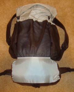 I made mine grey so it matches my quilt, hat, tent, and beard. ;-)
It seems to have plenty of room for my main gear and I've not used the side pockets yet. I expect to fill those with water during my Arizona hike in a couple weeks. My sleeping quilt gets stuffed in first to fill the bottom and raise the heavy stuff up a bit. I don't squish the quilt down too much, but use the weight of gear above it to compress it down.
I just have one section of a blue foam pad for the back. Most people use a foam pad for sleeping and fold it up to provide the pack structure here. I'm using an inflatable pad instead, but it's 72 inches and I need 78 or my feet are on the ground. So, I lay the pack under my feet and have plenty of insulation and comfort there.
There is quite a bit of stress on the pack where the shoulder straps and waistbelt connect to the pack since this is where all the weight hits. I've double bartacked those points and the material seems to be plenty strong to handle the stress. I guess we'll see as I make my way from Mexico to Utah next month.
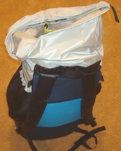
The top has a drawstring and two velcro strips to hold it shut. This top collar can also be extended up if you have a big load. But, be careful about overloading the pack - it's lightweight and should not have more than 25-30 pound load in it.
You can see how the pack top loads here. By packing sleeping gear first, you don't need to dig deep until it's time to set up camp. Keeping the daily needs, such as food, water, maps, hat, filter on top or in mesh pockets makes rest breaks easier to manage.
Oh, the two alterations I made?
- I attached the pack back and sides incorrectly which subtracted about 400 cubic inches of the bottom area.
- One seam on the collar faces out rather than in - I blame that one on the instructions, though.
Hike On
02/21/2012
2B2B
 2 Busy 2 Blog
This entire past week, I've been too busy to blog. But, today I got to take a big breath and relax!
In a nutshell, here's what I've accomplished:
- Finished sewing my backpack (pics soon)
- Sewed a 2nd sleeping quilt (thinner than first)
- Hiked about 40 miles (hills with my trek poles)
- Presented Wilderness First Aid training all weekend
- Got a couple new supporters of my long hikes
- Got new shoes for my AZ hike
I emailed some boy scout troops in Arizona, letting them know about my hike plans for the Arizona Trail and how they can join my ScoutStrong Challenge - you can too. Some are hoping to hike with me somewhere along the trail. One guy might let me stay at his cabin. And, another might help me reach the trailhead and hike the first few days with me.
I've also chatted with some AZ hikers online and they've been very helpful with trail, water, and planning questions. It's looking like I might have a place to crash in a handful of towns along the trail which will be so cool!
Hike On
Leave Comment
Posted: 02/21/2012
Posted: 02/21/2012
02/14/2012
Don't Forget
 Between all your meetings, exercising to stay in shape, starting on taxes, deleting spam emails, checking out youtube videos, and the millions of other things that take up your time today - don't forget.
Even if you hate chocolate - don't forget.
Even if you feel it's just a Hallmark Holiday - don't forget.
Even if you think killing flowers goes against Leave No Trace ethics - don't forget.
Hike On
(and don't forget)
Leave Comment
Posted: 02/14/2012
Posted: 02/14/2012
02/12/2012
AZT Maps
 One step closer to being ready for the Arizona Trail.
I received a brand-new map set on CD of the entire 800+ miles of trail on Friday. The maps are 1:28,000 scale and each image prints on an 8.5x11 sheet.
These maps are very detailed and should be perfect for navigating. The AZT Association at aztrail.org has overview maps which are great for getting familiar with the trail, but not detailed enough for navigating.
Now that I have these maps and my compass, my navigation needs are met.
I spent yesterday printing and refilling my ink cartridge :-)
Printing front and back gives me 65 sheets to carry - that's almost a pound of paper! I plan to carry about a week's worth of maps at a time and ship the rest ahead in a bounce box. Every day, I hope to cover 3 pages of maps which is around 20 miles.
I'll mark spots where I take pictures or other interesting bits and then dump the used pages back in the bouncebox at the next resupply point.
These maps were created by, and being sold by ($25), Brett Tucker at simblissity.net but the profits go right to the AZ Trail Assocation for sustaining the trail. Brett has done an excellent job on an extremely useful project to benefit the hiking community.
Hike On
Leave Comment
Posted: 02/12/2012
Posted: 02/12/2012
Older Posts Newer Posts
Find more Hiking Resources at www.HikingDude.com


Follow Me
Recent Comments