
Hiking Dude Blog
2024 - Nov Sep Aug Jul Jan
2023 2022 2021 2020 2019 2018 2017 2016 2015 2014 2013 2012 2011
07/26/2013
Rest Stops
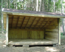
 Most of the Arizona Trail takes hikers through wilderness where you can camp anyplace you wanted within 15 feet of the trail. The Superior Hiking Trail has designated campsites every few miles. Unfortunately, much of the Ice Age Trail route is through populated areas and private land. It's not proper to just drop your tent in someone's backyard or even on their back 40 acres.
 Consequently, a fairly big challenge of thru-hiking the Ice Age Trail is finding places to camp for the night. The Ice Age Trail Association is working hard to create 'Distributed Camping Areas' (DCAs) along the trail specifically for long-distance hikers. These DCAs are just open spaces where hikers can legally set up a tent - usually no water or facilities. There are only a handful of DCAs at this time, so what does a hiker do?
The IATA has some great volunteers and they've compiled a list of Trail Friends - folks that may be willing to have hikers camp on their property. I figure these wonderful people probably get asked for help often, so I've held off on contacting them. I'll call on them when it gets critical.
Instead, I've emailed Boy Scout troops and packs across Wisconsin that are in towns along the trail route. The last couple days have been great because I've received replies back from a few Scouters that have space for me to spend a night! I'm now down to less than 6 nights where I'm not sure what we'll do for camping.
I've also asked a couple friends about a stopover. If you know of anyone along the Ice Age Trail route in Wisconsin that wouldn't mind having a couple old guys crash in their yard, or hunting land, or wherever, please tell them to contact me. It would be greatly appreciated.
Hike On
Leave Comment
Posted: 07/26/2013
Posted: 07/26/2013
07/29/2013
New MYOG Pack
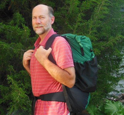
 My pack took quite a beating through the Arizona Desert and Minnesota north woods last year. It held up very well, but I wanted a backup "just in case". So, I ordered a new kit of materials from Quest Outfitters and made a nice green version this time.
For my needs, this pack is just great. The raw materials weighed 26 ounces and the final pack weighs 15.6 ounces. It easily holds all my gear and food for a week, and is comfortable. Quest Outfitters will sell you the materials as a kit and the plans with detailed instructions so you can make your own.
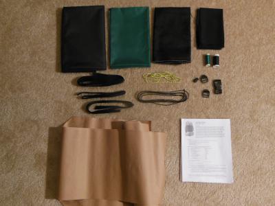
 The kit contains ripstop nylon for the pack body, stronger cordora for the parts that rub more, thick mesh for pockets, and fine mesh to make a sleeve to slip in a blue foam back support. There are also all the thread, buckles, velcro, gosgrain, elastic cord, and every little thing needed for your pack.
I had ordered the instructions and template last year, so I just reused them. I copied teh template pieces to brown paper as soon as I got them and use those rather than cutting up the original.
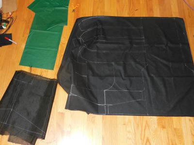
 The first step was to read through ALL the instructions to get an idea of how it all goes together. There are a couple mistakes in the instructions, I believe, and I've let Quest know abou them. They are minor.
Trace all the pieces onto the fabric. I laid them out as tight as possible to save fabric which I might use for some other projects. Quest provides plenty of fabric.
It's important to check that you are drawing on the 'back' side of the fabric so your marks don't show on the finished piece. And, ensuring that you are laying right and left oriented pieces for shoulder straps, belts, and the like is critical.
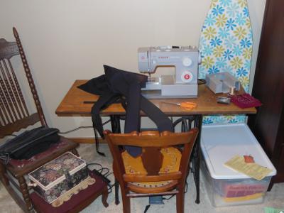
 Having a comfortable area in which to work really helps. Here's where all the magic happens! :-)
 Actually, a bright halogen floor lamp was a big help to keep the area brightly lit. It helped me find dropped pins in the carpet, too.
This is our new sewing machine since I broke our old, old, old one last year making my first pack. It wasn't my fault - a plastic gear inside just gave way, and replacing it didn't work out.
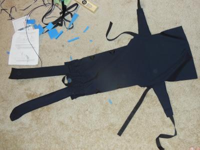
 The pack is built in sections. Here's the back section with shoulder straps and waistbelt. It is the most complicated part, and the most difficult to sew. After this, it gets pretty easy.
The front, right side, and left side are made. Then, all the parts are sewn together.
I made a few modifications from the original pack:
- I left off the back support sleeve since I plan to just slip a piece of cardboard inside the pack.
- I did not add the optional top cover since I'll have a rain poncho that covers me and the pack.
- I angled the side pockets so the fronts are a bit lower, letting my reach back with my hand and get in the pocket.
- I added little water bottle straps to the front shoulder straps so I have two bottles in front, balancing the weight and easy to access.
Well, for about $40 and two days of sewing, I'm happy with my MYOG pack. Hopefully, I won't need to use it until next year, but it's ready to go!
MYOG = Make Your Own Gear
Hike On
Leave Comment
Posted: 07/29/2013
Posted: 07/29/2013
08/01/2013
Papa Bear Arrives
 Papa Bear arrived by train from Seattle on Tuesday night - just a 13 hour delay - Go Amtrak!!
Yesterday, we visited REI and a couple other places. Today, we walked 10 miles. Tomorrow, we head to Wisconsin!
Here's Papa Bear on the trail this morning. Check out my current location on the map.
Leave Comment
Posted: 08/01/2013
Posted: 08/01/2013
08/03/2013
IAT Start
 we're on the trail!
Left Potawotomi Park trailhead at about 6am and are looking for breakfast in Sturgeon Bay soon. Check out my current location on the map.
Trail Journal
 We started hiking from the Ice Age Trail eastern terminus at Potowatomi park at 6am. Stopped for breakfast in Sturgeon Bay and continued on to Maplewood. There, we spied Richard's Grill and sfopped in. We met 3 guys and had a great time over a couple beers. Mark gaves us his extra string cheese and we were off again.
4 hours later, we're in Algoma at the Steelhead saloon having cheese curds and onion rings. It's a tough job, but...
Hike On
08/04/2013
Algoma to Ellisville
 I traveled about 30 miles today.
Super day with many miles! Weather continues to be perfect and the trail is smooth and wide. We met many people on the trail and it's fun telling them what we're doing. :-)
This tunnel was on the Kewaunee River Trail. We hiked to Kewaunee and had breakfast at Kunel's Korner. We continued on to Ellisville and are having dinner at the only (and best) place in town. They are happy to have IAT hikers eat and camp out back.
08/05/2013
Mishicot Trail Magic
I traveled about 21 miles today.
After a great night's rest behind Janda's, we were on the trail (road) at 6am. Rain threatened all morning but only succeeded in keeping the temps down for a perfect day of hiking.
Toaday was mostly road walking with a trail stretch through Tisch Mills and Mishicot.
Just as we were entering the new Mishicot segment, a truck stopped and the land owner introduced himself - he had just mowed the trail and was glad to see hikers using it. We thznked him for letting the trail pass through.
Entering Mishicot, we didn't know where we'd stay. I had lost info for my contact here. A vehicle stopped and a lady asked what we were doing. A short talk was followed with an offer to stay with her family. So, here I am, showered, fed, and on a soft bed heading to sleep - ready for another day thanks to more generous WI folks!
08/06/2013
Day 4 - Leaving Mishicot
 We left Mishicot after a terrific french toast breakfast using real home-made bread! We're on a road walk due east to the Lake Michigan shore followed by a nice, long trail walk to Manitowoc.
The short trail through Mishicot included this cool covered bridge that originally led to a brewery across the river. There is also a popular salmon run up to the Mishicot dam from the lake.
Hike On
Leave Comment
Posted: 08/06/2013
Posted: 08/06/2013
Mosquitos, finally
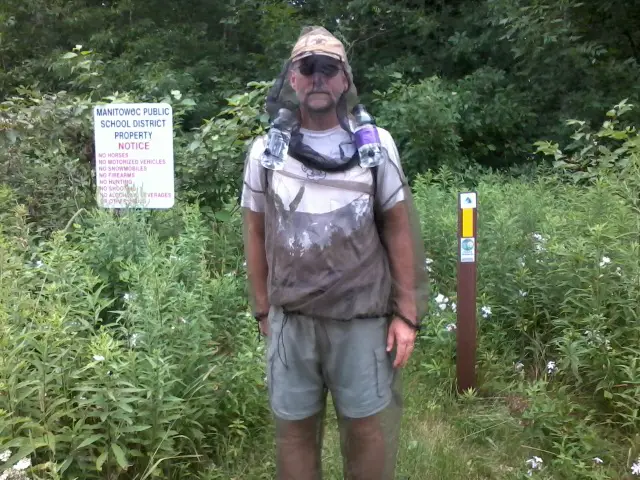 This morning, we've walked about 17 miles from Mishicot to Two Rivers via the Point Beach state forest. We found where all the mosquitos have been hiding!!! Our bug suits worked wonderfully and were a real fashion statement.
We have about 11 more miles today - it's a long one!
Check out my current location on the map.
08/07/2013
Trail Journal
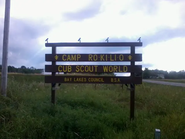 I traveled about 28 miles today.
Camp Rokilio Rox! We hiked here from Manitowoc today on almost all roadwalking. The hike wasn't too exciting but the destination is great! We arrived just at dinner and the staff was very welcoming. They are just starting their last session of Cub World for all cub scouts so the staff should be pretty tired - but you couldn't tell.
We've been given a cabin in which to stay and a scout staffer is driving us back to the trail early tomorrow. Oh, dinner was great too!
After dinner, I was asked to talk to the cubs and I just let them ask me questions for about 5 minutes. It was fun and there were still more hands up when we finished.
Leave Comment
Posted: 08/07/2013
Posted: 08/07/2013
Older Posts Newer Posts
All Comments:
Feb 13, 2020 - Jason Berklund
Hey hiking dude I have several questions planning my first north to south trip
from 270 all the way down. I kind a know what to wear what to eat all that
important jive. I am in relatively good shape definitely Not concerned about
where in tear. 45 years old going with a 21-year-old nephew. My question is
I have friends in Duluth that I don’t want to burden with driving me what’s the
best way to get up to otter Lake Road that’s not gonna cost a crap ton. We
were thinking 15 miles a day. We were also thinking hammocks. Let me
know what you think please. I have read so much and look at so much and
heard so many opinions but You seem to be very realistic on your
comments. Thank you
Feb 13, 2020 - Hiking Dude
@Jason - Hammocks work fine - most campsites have lots of trees.
15MPD is realistic, and you'll probably do more than that many
days.
Getting to the northern terminus is expensive (in my mind). If you can schedule correctly, Arrowhead Transit is cheapest to Grand Marais, but then Harriet Quarles is the only shuttle I know of. You might find a good ol' boy in Grand Marais willing to drive you the 35 miles to the end for a few $$$.
It's a 3 hour drive from Duluth - that's 6 hours and 300 miles round-trip. Maybe your friend would like to drive up the north shore for a day.
Feb 04, 2024 - John
Me and my fiance are going to Costa Rica for our honeymoon and we
are so excited!
May 02, 2024 - Zeke Mead
Has anyone cycled this Camiño? Sounds like the trail is a road
and if trucks are able to do it, maybe bikes too?
May 03, 2024 - Hiking Dude
@Zeke - Someone could certainly bike part of the Camino de Costa
Rica, but other parts are simple trail that would not be passable
by bike.
Ask a Question
Find more Hiking Resources at www.HikingDude.com


Follow Me
Recent Comments