Hiking Dude Blog
2025 - Aug Jul
2024 2023 2022 2021 2020 2019 2018 2017 2016 2015 2014 2013 2012 2011
05/24/2012
Google Map Photo Gallery
 Photos from my Arizona Trail hike are online now. I put them into a Google Maps / Google Earth file just for something different.
You can see a map of the trail with thumbnail images near the location where the photo was taken. This is done by using the time the photo was taken which is embeded in the photo by the digital camera and the tracking points from the Spot Messenger I used on my hike. The tracking messages contain a Lat/Lon location and the time. Some free software works its way through the waypoints and the photos and creates a KML file for Google to read. I used GPicSync, but there are other packages out there.
Google Maps views the photos in a web page. If you view the file in Google Earth, you can take a tour which automatically hops through the photos and locations. (Open KMZ file (200KB) in Google Earth)
Well, if you want to take a look, click the 'Map' link on my AZ Trail page. On that page, you can also check out gear, food, and expenses from the trip.
Hike On
Leave Comment
Posted: 05/24/2012
Posted: 05/24/2012
05/14/2012
AZ Trail Journal Ready
I've been quietly resting my legs and putting together my Arizona Trail Journal for the past week.
You can read all about my trek Right Here. I've included pictures from the trail, information about my homemade gear, and a daily record of the hike. I hope it provides you with helpful information, some tips, a little humor, and maybe gets you thinking about doing a longer hike yourself or with others.
A GoogleEarth map of the trail with pictures will be available pretty soon.
Hike On
Leave Comment
Posted: 05/14/2012
Posted: 05/14/2012
05/01/2012
Next Steps
Now that my little 800-mile hike through Arizona is over, I get to move on to other things. I plan to take a couple weeks to mostly rest up and ensure my leg is ok - probably need to see a doctor about that when I get home. Here's my list of things to do over the next few months:
So, I won't be bored. :-)
Hike On
- Present my story at District Roundtable. Show my gear and some pics and then answer questions from other Scouters. Hopefully I'll get them thinking about lighter weight backpacking possibilities with their scouts.
- Present Red Cross training. I've got a backlog of Scouters needing certification so they can go to Philmont, Seabase, and Northern Tier. Since I've been gone 7 weeks, I'm adding a couple more training sessions to make sure everyone gets training that needs it.
- Write my first book. This is the big one. I plan to write a handful of short stories from the trail for children. They will demonstrate human/nature interaction and include discussion outlines so teachers can use them for nature lessons. I'm very excited about this and look forward to working with my niece to make it a reality.
- Rest, then keep hiking. I have to make sure my legs are whole and secure and then I can start back up walking each day to keep in shape. I'd hate to just sit and eat and lose my fairly good heart/lung/leg development I received from walking every day for the past couple months.
- Let the local papers and TV know what I did. They might be interested in a short story. I'd also use that exposure to promote the ScoutStrong program a bit more.
- Catch up on my hundreds of emails that have accumulated while I was on the trail.
So, I won't be bored. :-)
Hike On
04/28/2012
Day 43 - Final Steps
 I walked 54461 steps on the trail today.
I traveled about 28 miles today.
I'm Done!
I reached Utah at 2pm today and PapaBear was waiting to take me to Phoenix - we're on our way now.
I overdid it the past few days and my legs really hurt, but nothing serious. The actual hiking today was fairly easy and the painted desert at the end was beautiful.
If someone from troop 479 reads this, please tell Benjamin M. to take a look.
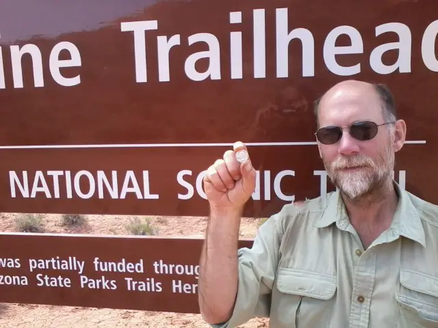
This pic is of me at the end of the trail holding a solid silver 1961 quarter that Benjamin and his dad gave me for my trip. They said it might come in handy for trading since it is silver. I carried it the whole way and it often reminded me of everyone back home that I would see soon. It will forever remain one of my favorite things I've collected over the years. It's extra special because it was made the year I was born.
Day 42 - Smelling the Barn
 I walked 56314 steps on the trail today.
I traveled about 28 miles today.
PapaBear drove me to where I hitched a ride. I walked back up to the trail and hiked it Jacob Lake. Now I just need to do 28 more miles tomorrow. Kind of like the farm animals getting close to home and getting anxious to finish up.
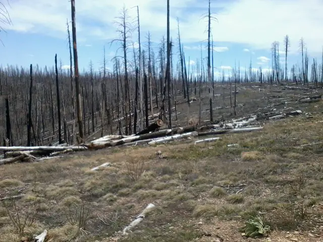
I saw a small herd of 8 or 9 deer. Other than that, most of the day was spent walking through this big burned out area.
It was fun to top and have lunch at a trailhead with PapaBear, then off hiking through the afternoon.
Leave Comment
Posted: 04/28/2012
Posted: 04/28/2012
04/26/2012
Two Days to Go
I've not had coverage to send posts since the south rim of the Grand Canyon so a flurry of updates were just posted - don't miss 'em.
I finally met up with PapaBear and we're all set for the end of my hike. Tomorrow, he'll take me back to where I stopped and I'll hike about 30 miles. Then, I'll finish on Saturday and we'll head toward Phoenix.
I probably won't be able to post until Sunday since there seems to be no t-mobile in the area. (we're at a restaurant in Utah right now and hading back to Jacob Lake in a minute)
Walt and Jake
 Here at the Jacob Lake Inn, I've met a few of the nicest young folks on my hike. It's a small and comfortable inn with souvenir shop, small 'junk food' store, and fun diner area.
Jake was handling the diner when I came in. I sat as far from everyone else as I could since I hadn't showered. ;-)
Jake was friendly, efficient, and extremely helpful. He's a college student in Idaho. The food was good, especially the chocolate shake.
Walt does registrations and (as far as I can tell) pretty much everything else as needed. I've never met anyone as conscientious, carrying for the comfort of others, and seeming to enjoy their job as Walt. His fast smile is contagious and his efforts to make everyone welcome is admirable. He got weather forecast info, showed me the way to a local lookout tower, and even insisted I use his personal cellphone to call home when mine had no coverage.
A couple girls working here seemed just as good as Walt and Jake, but I didn't really talk with them.
A funny thing - these guys have just started working here as summer jobs so they are still learning. When I ordered my shake, neither Jake nor Walt knew how to run the shake machine so they got another buddy to do it. I have to say, it was one of the best chocolate shakes I've had. Thanks, guys!
Leave Comment
Posted: 04/26/2012
Posted: 04/26/2012
Day 40 - Out of the Canyon
I walked 44426 steps on the trail today.
I traveled about 27 miles today.
After a very warm night down in the canyon, I hiked out the north rim. Simply spectacular scenery the entire way. The trail was terrific and the hike went quickly even though my left leg is nearly shot.
On the north Kaibab, there is usually still snow this time of year. There's less this year, so I took off on the trail - immediately hitting some drifts. To get water, I dropped off the trail to the road where there was a small lake. That's when Marshal, the biker, caught up to me so it was fortunate I did that bit of road walk. I rejoined the trail at the Natl Park entry station, heading east back into the forest. Immediately, I hit more snow and saw only 1 set of footprints through it. I followed for almost 3 miles over mostly clear ground but some knee-plus deep drifts.
If it was sunny weather, I would have continued but it was sprinkling all day, temp dropping, and forecast of fairly severe storm coming. With no GPS, I knew I couldn't follow the trail the next day if it snowed. Being a wimp and opting for safety, I bailed off the trail and walked 10 miles down some forest roads to the main Hwy 67. I walked it for a few miles until a couple guys doing work on the rim stopped and gave me a ride to Jacob Lake. They were 2 Navajo men heading home to NM and were great to stop and help a stranger. Thanks, guys!
So, when I got to Jacob Lake, I phoned Marshal from the lobby, got a burger dinner, and then a great bed and shower.
All in all, not a bad day even though I will not hike the whole trail due to snow. We'll see what tomorrow brings.
Leave Comment
Posted: 04/26/2012
Posted: 04/26/2012
AZ Trail Biker
 You may remember I was passed by a biker on the trail days ago and he was racing the entire trail. Well, I met another one hiking down into the canyon. His name's Marshal. Since they can't ride through the canyon, they have to 'hike-a-bike' for about 20 miles from the south rim to the north. Marshal was planning to do this in one shot since he didn't have a permit to camp in the canyon.
After passing him, I tried to figure out how I could help. I tries to call the number on my permit to see if I could add a persn - no coverage. I kept my eyes out for a ranger that might change it for me - none around. Finally, when I got to Cottonwood camp, I asked the individual campsites there if they possibly had a permit for more people than were actually in their group - jackpot!
When Marshal drug into camp around 7pm, a spot was open to him and he got to rest before climbing the north rim the next day.
He got an early start but I caught up to him. We talked as we walked which made the hike less arduous, but no less steep. He gave me some 'RockTape' for my sore leg and I eventually moved on ahead. Once the rim top was reached and he could ride, he overtook me on the way to Jacob Lake where he decided to spend the night in a hotel.
How do I know? Well, I hitch hiked and got a ride and bummed his spare bed! More about all that next.
Canyon Pics
Older Posts Newer Posts
Find more Hiking Resources at www.HikingDude.com


Follow Me
Recent Comments