
Hiking Dude Blog
2025 2024 2023 2022 2021 2020 2019 2018 2017 2016 2015 2014 2013 2012
2011 - Dec Nov Oct Sep Aug Jul May Apr
12/31/2011
Resolve
 Another year about to begin - endless possibilities and opportunities ahead. Over the holidays, I've been enjoying time with relatives and away from computers. I got in a couple 15-mile hikes in the snow, received a few very cool hiking/camping items, and ate way too much. I'll tell you more about the first two next week. I even made two sets of moccasins for gifts and have one more to do today.
It's always a good thing to take some time to reflect on what you've accomplished and make goals you'd like to attain. January 1 is a perfect date to do this, being sort of a reboot of time each year. Being resolute is a characteristic of good leadership and self-discipline - defining success and then pushing ahead until success is reached.
If you've not made any new year's resolutions yet, take ten minutes and jot down a few so you can check your progress over the year. Here's a couple of mine:
- Walk 3000 miles - that's 800 on the AZ Trail, 1100 on the Ice Age Trail, and 1100 on conditioning hikes.
- Blog 300 times - this will be the most difficult
- Make 30 new friends - not Facebook friends, real people. I hope to meet them on the trail, at presentations, church, and in business.
Now, I need to set my resolve and make these more than just wishes.
Hike On
(and have a Happy New Year)
Leave Comment
Posted: 12/31/2011
Posted: 12/31/2011
12/14/2011
The Cold Won't Kill Ya ...
 On this hike, it was 5 degrees - see the frost all over my head? :-)
I've decided 5 degrees is about as cold as I enjoy being out hiking miles. Colder and the layers of clothes make walking less enjoyable. But, down to 5 and my trail shoes, longjohns and nylon pants, fleece jacket and rain coat, mittens, hat, and scarf work perfectly without being overly bulky. This week it's popped back up to 40 with mist and fog so I've got at least a few more days to hike.
In wilderness first aid, we discuss what time of year is the most dangerous for hypothermia. When your body loses more heat than it can generate for long enough, your core temperature drops, resulting in hypothermia. Often, the first thought right out of the gate is 'January!' but then we chat a bit.
Hypothermia can happen any time of year, but the colder the temperature gets, the faster your body loses heat. So, January makes sense. But, in the dead of winter around here with -20° days, we expect cold so we wear parkas, mukluks, mittens, and balaclavas to insulate us. Besides that, and just as important, everything is frozen solid - that means it's not wet. You can hike through miles of snow and stay completely dry.
Staying dry is a great defense against hypothermia. Hiking at a steady rate without working up a sweat, dressing in layers, ventilating your clothes, and wearing rain gear are all good ways to minimize moisture on your skin. Water transfers heat 50+ times as much as air.
So, spring and fall tend to have more wet weather. Which is worse?
After warm summer days, a wet Fall day feels cold so we protect ourselves. A 35 or 40 degree day in Spring feels tropical and people are tempted to go out with inadequate protection - especially youth. When they get wet, real trouble can happen quickly.
Whether heading out for an afternoon hike or a long trek, staying warm and dry should be part of your preparation.
The cold won't kill ya - the wet will.
Hike On
Leave Comment
Posted: 12/14/2011
Posted: 12/14/2011
12/05/2011
Cairns
 I'd like to elaborate on two points that came up in the comments of my last post - and thank you for all your thoughts.
Cairns vs. Art
Some people mentioned that rock cairns are useful for marking the trail so the rock stack I found should be left alone. The rock stacks were most definitely NOT cairns. The trail is manicured and so encompassed by forest that a person would need to work at getting off the trail.
Rock Art does not adhere to the ethics of Leave No Trace. Some of the specific LNT items to consider are:
- Use a map and compass to eliminate the use of marking paint, rock cairns or flagging.
- Leave rocks, plants and other natural objects as you find them.
- Do not build structures, furniture, or dig trenches.
- Respect other visitors and protect the quality of their experience.
If a person subscribes to the LNT philosophy, then piling rocks isn't something that person would do. It is something we should be teaching youth not to do when we have the opportunity.
There is certainly a place for rock art, and nature art in general. Some people make a living from it - see Andy Goldsworthy. But, we shouldn't be building artworks in the wild, or on public lands, and leaving them for others to observe after our hike.
Building Cairns
Cairns are definitely useful in some areas. Many land management groups build and maintain cairns to mark the trail, similar to blazes on trees. For example, see this cairn construction page. A group spends time removing unofficial cairns and rock art to improve the usefulness of the maintained cairns.
In a pristine environment, hikers should have the opportunity to feel like they are the first explorers. No trail markings are needed through an area with no trail. Cairns in a pristine area may concentrate traffic to a specific path, creating a trail counter to LNT philosophy, rather than dispersing traffic to keep the area pristine.
In an area with established trails, cairns or blazes made by the responsible land agency are adequate. Individuals adding to them can cause confusion and unneeded visual impact.
Here are a couple other pages you might review - Leave what you find, LNT Blog
If you are a proponent of LNT, please take care in how the philosophy is shared with others. You can do it reasonably in an effort to help others understand the value, or this way - http://www.youtube.com/watch?v=Jdfr9x8M8Vw
Hike On
Leave Comment
Posted: 12/05/2011
Posted: 12/05/2011
11/30/2011
Appropriate Art?
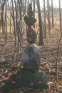 After my hike last weekend, I'm pondering something. I found this, and a few more, balancing rock formations that someone created along the trail. I think they look pretty neat and I've seen them done as art before.
The quandry comes from the location of this person's efforts. It is in a state park and along a well-trafficked trail. Most people come here, I believe, to walk through the woods and enjoy the natural beauty around them. None are expecting man-made artistic structures along the trail.
So my perceived dilemma is, should I admire the rock pile and leave it as I continue my hike, or should I take off each rock and toss it out into the woods?
The first response recognizes the efforts of the person and leaves the art for others to enjoy because it really does look pretty cool. The second puts more importance on the natural beauty and feeling that the wilds are unspoiled, and also supporting the minimal impact and leave no trace ethics.
If I were to encounter this in a wild area, my choice would easily be made to dismantle the structure. In my view, the wilds should remain as natural and wild as possible and man-made impacts should be removed.
But, this was along a frontcountry trail where folks hike for an hour or so and there are rest benches, toilets, water fountains, and picnic tables in the area. For all I know, it's possible this art was approved by the land manager to make the trail more interesting. After all, lots of other people have walked past them and left them there.
In this case, I left them alone but have sent an email to the Department of Natural Resources contact to ask what they would prefer to have done with them.
Whatever the response (I'll let you know), I do hope we all agree that it is not our place to create artistic sculptures, structures, drawings, or whatnot out in the public wild places. Minimizing our impact and allowing future visitors to experience as wild and natural a place as we enjoyed is our duty.
Would you have taken the rock piles apart or left them for others to enjoy?
Hike On
Leave Comment
Posted: 11/30/2011
Posted: 11/30/2011
11/29/2011
First Steps
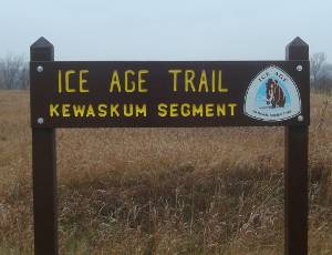
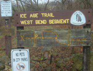
 After just researching, planning, and training for the past few months, I finally set foot on one of the national scenic trails I plan to thru-hike in 2012. Over Thanksgiving break, I got a taste of the trail by hiking the Kewaskum and West Bend segments of the Ice Age Trail plus the connecting routes between them. It was just 14 miles with on-and-off drizzle but was a wonderful hike!
The volunteers that maintain those segments have done a great job. Along the way, there were four or five placards that described the terrain from the glaciers, the people that created the trail, and other interesting tidbits. If the rest of the trail has such kiosks, and well-marked routes, it will be a wonderful trek.
I did notice that someone had vandalized some of the trail signage - what a shameful way to waste money, effort, and time put out by volunteers to improve life for all of us.
 Not all the trail blazes are easy to find, though.
Walking down a sidewalk in West Bend, I could have easily walked right past this pole if not expecting the cut-off into the forest. I found that I got tuned into keeping an eye out for yellow blazes and had no problems.
I stopped at a gas station for a Snickers bar and almost asked the clerk if he knew about the Ice Age Trail just to see. I can see I'll have to work on being a bit more outgoing with strangers to get the most fun out of these hikes. Just a bit over 3 months before I start for real.
Hike On
Leave Comment
Posted: 11/29/2011
Posted: 11/29/2011
11/22/2011
GeoPal Pedometer
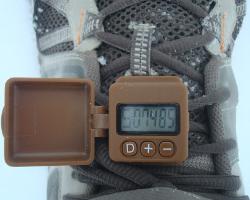 You may have heard that the Appalachian Trail takes 5,000,000 (that's 5 million) steps to thru-hike. Well, my legs are longer than most, so I thought it would be fun to find out exactly how many Hiking Dude steps it takes to thru-hike the scenic trails. After I've hiked a trail, I'll post my step count on the informational page for that trail. Last month, I started looking around for a good pedometer to take on my hikes.
At just the perfect time, an opportunity to test a new GeoPal pedometer came up at OBN and I got chosen as a participant. So, I've been wearing a GeoPal on my hikes for the past week or so to see if it does what I need. I just clip it on my shoelace and walk - pretty simple. When I get home, I look at the number of steps displayed.
It's a very cool little gadget, doing more than just count my steps - which it does very well. It's an accelerometer pedometer which is better than pendulum design. It has the date and time so I don't really need a watch. It stores 21 days of data, automatically starting a new day of steps at midnight. You can wear it on your wrist, hip, or shoe - I use the shoe so it's out of the way and more accurate.
The market for GeoPalz is youth, with a goal of increasing physical activity levels by making running around rewarding. To reach this goal, they've created a fun website called GeoPalz.com where kids can track their steps and earn stuff, ranging from frisbees to gift cards - I've already got almost enough steps for a sports bottle! Each person can set up their step length, height, weight, age, and other details to accurately track miles walked and calories burned. That's probably more interesting to parents or someone on a fitness program. My favorite part of the GeoPalz website is a map that automatically shows how far you walked, from your hometown to neighboring towns. As your accumulated miles grow, you reach distant towns.
Since GeoPalz are aimed at youth, the pedometers have tons of different emblems from which to choose to make them more personal, from butterflies to skateboards. In my case, I didn't really want to walk aroud with a flower on my foot, so I trimmed off the soft plastic piece, reducing the weight of the device as well - it's just 0.6oz now. It has a very strong clip and dust/water cover that I could remove and probably drop it to 0.3oz but I'm not that much of a gram weenie.
I plan to keep tracking my training hikes and then wear my GeoPal across Arizona in the spring. I'll let you know how many steps it is from Mexico to Utah, and other trails after that.
Hike On
Leave Comment
Posted: 11/22/2011
Posted: 11/22/2011
Older Posts Newer Posts
Find more Hiking Resources at www.HikingDude.com


Follow Me
Recent Comments